Locally Sponsored Research
Guam Comprehensive Monitoring Program
The United States Geological Survey (USGS) has monitored our island’s water resources since 1951. Unfortunately, during the 1990s they were forced to downsize this program because matching support from the Government of Guam was discontinued. This resulted in the abandonment of all deep monitoring wells needed to monitor saltwater intrusion in the north, and most of the stream gages in the south by the mid-1990s. In 1995, the USGS closed its field office at Naval Station, but continued to run a limited monitoring program (out of its Saipan and Honolulu offices).
August, 1998, the Comprehensive Water Monitoring Program (CWMP) for Guam was made a permanent part of WERI’s program when Governor Gutierrez signed PL 24-247. This resulted in the refurbishment of the deep monitoring wells and a renewed program of water resource monitoring on Guam. The intent of PL 24-161 was to restore, and then to expand, as needed, the discontinued monitoring program in order to help Guam manage and safeguard all of its freshwater resources, now and in the future. Under PL 24-161, WERI/UOG and the USGS entered into a memorandum of understanding to administer and fund this program on a 50/50 cost-sharing basis. The CWMP is a permanent investment in Guam’s future.
A well-designed long-term CWMP can save communities millions of dollars, and even human lives, by providing critical information for water-supply, culvert and bridge design, delineating flood-hazard areas, and tracking effects of climate change. The USGS started a water-resource monitoring program in Guam in 1951 with installation of stream gages at Pago, Lonfit, and Tolaeyuus and a rain gage near Fena dam. At the same time, measurements of discharge from Almagosa Springs and water levels in Fena Reservoir started. Since 1951 about 22 continuous streamflow, 8 rain, and 16 groundwater monitoring stations have been operated, providing reliable information on the water resources and hydrologic hazards of Guam.
The current monitoring program consists of 8 continuous-recording streamflow gages, 6 continuous-recording groundwater wells, 6 groundwater wells where the thickness of the freshwater lens is measured, and 5 continuous-recording rain gages. From a broad perspective, the program provides long-term information on the hydrologic cycle of Guam so that its water resources can be understood and sustainably managed. The bulk of the monitoring stations on Guam are funded as part of a Joint Funding Agreement between the USGS and WERI.
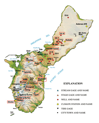
Locations of USGS monitoring stations on Guam
Back to top ^
Stream Gages for Water Availability and Flood Planning in Southern Guam
Most freshwater used in southern Guam comes either from streamflow or wells that withdraw water from near the banks of streams. Data from USGS stream gages provide information needed by managers and engineers to properly manage the long-term sustainability of these water resources. Statistical analysis of long-term streamflow data are needed so the effects of abnormally wet or dry years can be understood and planned for. For example, USGS gages provide information that can be used to assess and manage the sustainability of surface water from the GWA Ugum Treatment Plant. Other gages, funded in cooperation with the U.S. Navy, are used to manage withdrawals from Fena Reservoir.
*Flow in Pago Stream has been measured since 1951.
Long-term streamflow information is needed for flood planning. This information is used to delineate flood zones, estimate the magnitude of floods and frequency with which they could be expected to occur, and design bridges and culverts. For example, information from 11 stream gages and 3 other sites was used to assess the flood peak magnitude and recurrence interval following Typhoon Chata‘an in 2002. FEMA uses information from USGS stream gages to determine the level of financial aid from FEMA after storms. Currently, the WERI-USGS CWMP funds the operation of 5 stream gages at key locations in southern Guam.
Back to top ^
Well Monitoring of the Northern Guam Lens Aquifer
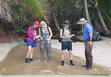
*WERI field assistant measures water levels in the Northern Guam Aquifer.
Monitoring wells operated as part of the USGS-WERI CWMP provide information to assess the health and sustainability of the Northern Guam Lens Aquifer. This aquifer is the most important source of freshwater on the island. Currently, the program includes 6 wells where water level is continuously measured and 6 wells where the thickness of the freshwater lens is measured quarterly. Collectively, this information allows scientists at WERI, GEPA, GWA, and USGS to understand the flow of water through the aquifer and refine sustainability estimates of this resource.
This information is used to understand how current levels of pumpage are affecting the aquifer and how future changes in climate and groundwater production may affect the sustainability of groundwater resources. Coupled with detailed geologic mapping and modern hydrologic tools such as groundwater flow models, information from this long-term program will be invaluable as additional water is needed to support increasing economic development on Guam.
Back to top ^
Rainfall Data to Estimate Water Supply Recharge and Flood-Water Distribution
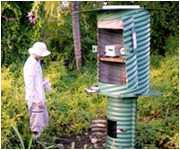
The USGS currently operates 5 rain gages on Guam, 4 of which are funded by the WERI-USGS CWMP. Rainfall data are fundamental to understanding the water supply and threats from flooding. Information from these gages is used to evaluate the extent of drought during El Nino events and the severity of flooding during typhoons. Information from rain gages is also essential in determining how much freshwater infiltrates past the ground surface to reach the water table. This water, known as recharge, is the source of freshwater in the Northern Guam Lens Aquifer and only by measuring rainfall can its abundance be accurately estimated.
Back to top ^
Sediment Measurements for Watershed Management
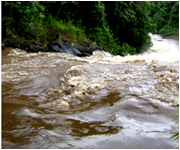
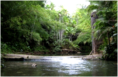
*Ugum River after heavy rains transports large amounts of sediment to the coast and severely impact coral reefs. Knowing the sediment sources and amounts discharged can assist managers in the design and implementation of mitigation strategies.
Coral reefs on Guam are thought to be damaged by sediment carried in runoff from watersheds. Managers are trying to understand the sources and amounts of sediment moving from watersheds to coral reefs so that this problem can be addressed. Successful watershed restoration may result in reduced soil erosion and sediment transport to coastal waters, thereby increasing compliance with the Clean Water Act. Streams may also become better habitats for native stream organisms if sediment load is reduced. As part of the WERI-USGS CWMP, two stream gages in southern Guam have been upgraded with specialized equipment that automatically collects water samples so that the amount of sediment flowing to the ocean can be measured.
Back to top ^
What does it cost to operate a stream flow and other gages?
In 2010, the cost to operate a continuous-record streamflow gage will be $22,400. This includes all operation and maintenance, site visits, field data collection, data analysis, and computation of the flow record. Gage operations are frequently reviewed and upgraded as improvements become available. Determining the suspended-sediment load at a gage increases the annual cost an additional $26,880. Other gages, such as rainfall ($10,750) and groundwater ($6,720), require less funding. With over 100 years of experience, USGS procedures ensure that data are reliably collected, analyzed, and publicly available.
How can one get USGS water resource information?
Most data from USGS gages are readily available on the internet. As part of CWMP between WERI and the USGS, historic data and other hydrologic information for Guam are consolidated and made publicly available at: http://hi.water.usgs.gov/studies/guamlens/ .
Back to top ^