INTRODUCTION
Practically all field-oriented research relies, to some extent, on aerial photography. At the very minimum, a researcher desires to achieve a comprehensive view of his/her study site. More often, however, one desires a range of images covering a wider area or several different sites. Occasionally, the availability of aerial imagery even inspires new research.
Prior to the implementation of this project, most aerial imagery readily available for Guam was orthorectified. Such geometrically corrected images simulate a view from directly above and are equivalent to maps. While undoubtedly very useful, orthophotos do have certain drawbacks that derive from their almost complete vertical perspective. For example, their interpretation requires some prior experience as the look of many objects from directly above can be unfamiliar to the user; certain features are not be visible due to the vertical line of view and cloud cover; orthophotos sometimes lack true colors and aesthetic quality; finally, they are difficult to keep organized and their content is rarely instantly identifiable with a particular location.
The aim of this project is to provide oblique aerial imagery that can be relied upon in specific applications where orthophotos are not ideal. Oblique photographs are taken with the camera axis tilted: in other words, they are not vertical. Oblique images do provide, however, an inherently natural perspective, which the human brain interprets without effort. Oblique views of various features and objects are familiar to all users, regardless of their prior experience. Oblique aerials permit easy visualization of the spatial relationships in a given area and can positively influence the user's observations, thinking, and conclusions. In addition, quality oblique images are appealing material for use in publications, reports, and presentations, etc.
The advantages that oblique aerial photographs of Guam have over their orthophoto counterparts are most apparent in coastal areas. Many coastal features, such as the height of cliff lines, rock collapses, erosion scars, sea caves, etc., are hardly identifiable on orthophotos, but very apparent on oblique aerials. The fact that its coastline represents Guam's most dynamic environment and an amazingly diverse and fascinating area is very important. It not only best showcases the beauty of our island, but also represents the focal point of many recreational activities, educational projects, scientific studies, and government plans. Therefore, we made the island's coastline the focus of this project. Unlike most other similar photography, however, which is generally limited to specific locations and picturesque views, our aerial imagery provides an uninterrupted photographic array and the only seamless representation of the entire coastline of Guam.
PHOTOGRAPHY
All images acquired over the course of this project and contained in its database are oblique aerial photographs. They were taken by hand-held Nikon D70s and D40 digital cameras from a Cessna 172 Skyhawk aircraft, operated by Micronesian Aviation Systems and, in one instance, by Freedom Air. On each flight we flew either along particular segments of Guam's coastline or around the entire perimeter of the island. On certain flights we maintained a constant elevation and distance from the coastline (1000 feet high and 1000 feet seaward from the coast) and continuously shot uninterrupted arrays of photographs from a steady angle. These images became the material for stitching the seamless continuous image of the coast. On other less constrained flights, we shot general views and close-ups of individual features; these images became the bulk of the database.
The photographs include both low angle (showing only the land or the ocean's surface) and high angle (including the horizon) oblique images. We worked at various times of the day to take advantage of the best lighting in different areas. East and west coasts were best photographed in the morning and afternoon, respectively, when low angle sunlight rendered vivid colors. The north part of Guam between Ritidian and Pati points was the most difficult to photograph, as the coastal cliff line there is shaded most of the time. For that reason, the quality of the images from that area is somewhat lower than from the rest of Guam. In order to ensure greater detail and no cloud cover, the vast majority of images were taken from an elevation of 1000 feet, with fewer from 500 feet and fewer still from 2000 feet.
All photographs, totaling more than 4,800 images, were taken over the course of two weeks in February 2007.
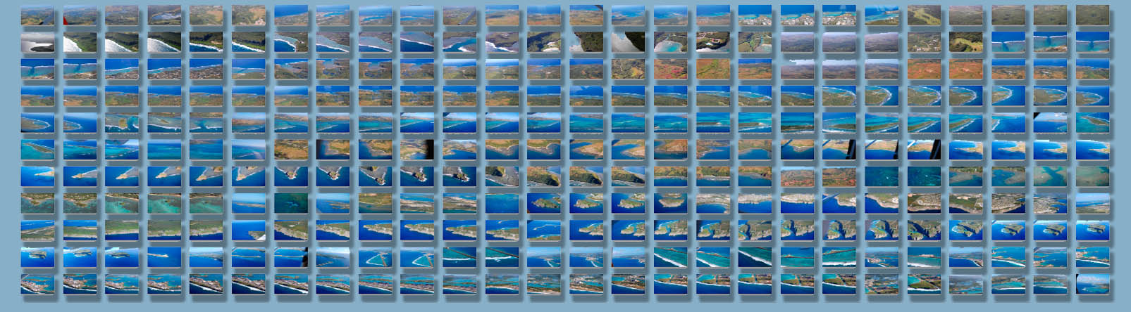
Fig. 1: A few hundred sample images taken as part of this project.
SEAMLESS IMAGERY
The hallmark of this project is the continuous image of the entire coastline of Guam. This extremely long seamless composite image was created from more than a thousand individual photographs. It is truly unique in the sense that it covers hundreds of miles of coastline in a single view that is both comprehensive and detailed. These photos were primarily taken from a constant angle, elevation, and distance from the coastline, then subsequently matched and stitched, using a range of software techniques.
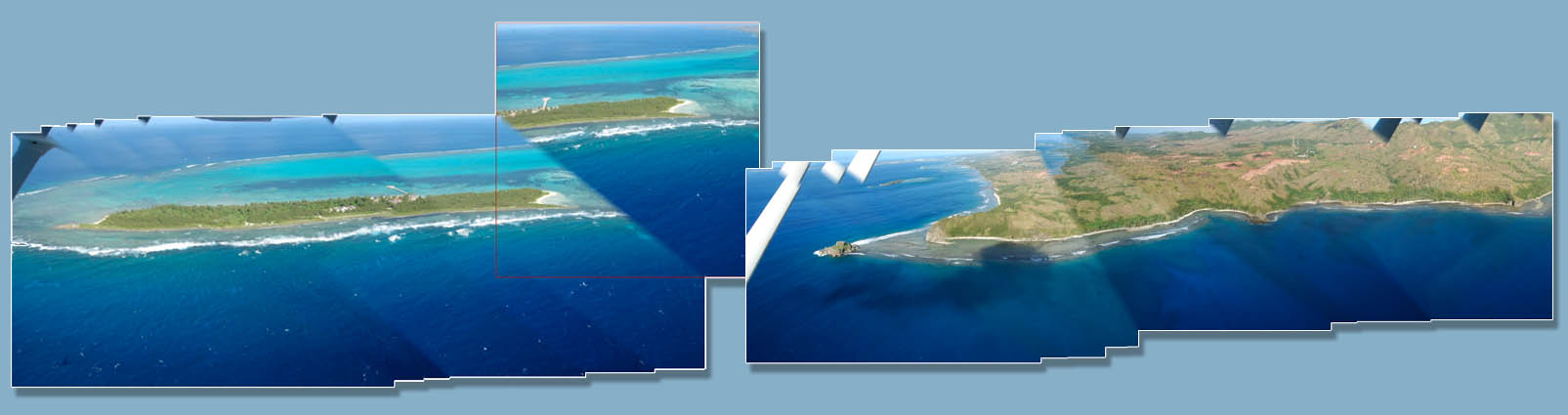
Fig. 2: Initial matching and overlaying of images.
The main difficulty in stitching photos is parallax. This phenomenon is caused by the change of position of stationary points relative to each other when seen by a moving observer. As we took photos from a moving aircraft, the natural focus was the coastline, which resulted in the more distant objects, such as buildings and hills, appearing directly behind different coastal points in different images – depending on the camera's perspective. When we later attempted to match the individual portions of the coastline together perfectly, the matching was far from perfect in the background inland areas. The parallax caused multiplication of far objects; therefore, in order to ensure continuum at the coastline, certain inland areas appear as double or multiple objects, although in reality, are single objects. Several techniques have been employed to correct this, but nevertheless, users will notice many evidences of parallax in the continuous image. The greatest challenge occurred in places where the coastline is fronted by wide fringing reefs, in which case it was impossible to match the reef and the coastline behind it perfectly. Always giving precedence to the coast, we have created an image that is most accurate at the coastline itself, and progressively less so in the foreground and background. Considering that parallax prevents even panoramas taken by stationary camera from being stitched perfectly, we believe that our continuous representation of Guam's coast, acquired from a constantly moving aircraft, represents the best possible such image. Additional problems were posed by attempting to maintain the camera vertically at a constant downward angle, and at the same time keep it horizontally 90 degrees to the undulating coast, neither of which is feasible. This caused the series of stitched images to deviate from the ideal horizontal layout.
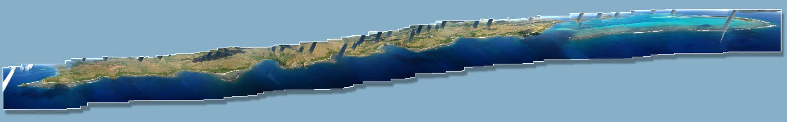
Fig. 3: An early version of a stitched image series.
After rotating and cropping the photograph to a satisfactory horizontal layout, a great deal of time was spent erasing ghost images and parallax artifacts caused by the stitching process and removing the aircraft's top wing, which often obstructed the view. Ultimately, we were able to produce an image to our satisfaction. It shows the entire coastline of Guam in virtual continuity, with breaks only in a few places where the aircraft was forced to take sudden turns due to sharp bends of the coastline.
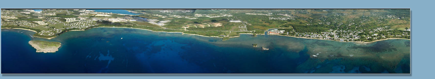
Fig. 4: Part of the continuous image of Guam's coast.
ANNOTATIONS
The continuous image of the coast has been annotated with various superimposed layers of information, in order to further enhance its utility. The first step involved indicating the major coastal features such as bays, points, beaches, and reefs and identifying them by name. The spellings of place names are according to official U.S. toponymy as indicated on standard maps and references.
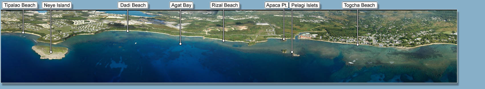
Fig. 5: Part of the continuous image of Guam's coast with major place names superimposed.
Further significant sites, such as National Park and Wildlife Refuge areas, military bases, hotels and other major buildings, various landmarks, etc., were identified in another layer containing additional annotations.
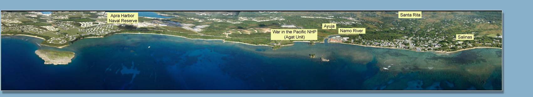
Fig. 6: Part of the continuous image of Guam's coast showing additional annotations.
The third superimposed layer identifies rock formation labels exposed along the coastline. This information is based on the Geologic Map of Guam. The rock formation labels, which are superimposed on the image, are consistent with abbreviations, as well as with the color labels used on the geologic map. This allows the user to easily interpret coastal geology and quickly locate rock outcrops of interest.
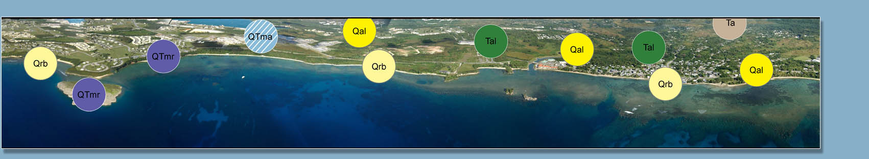
Fig. 7: Part of the continuous image of Guam's coast identifying major rock formations.
Finally, very approximate geographic coordinates were added to the image. This annotation layer contains the latitude and longitude estimates for each of the zones that the coast was divided into for the purposes of this project. White vertical lines show divisions between the zones.
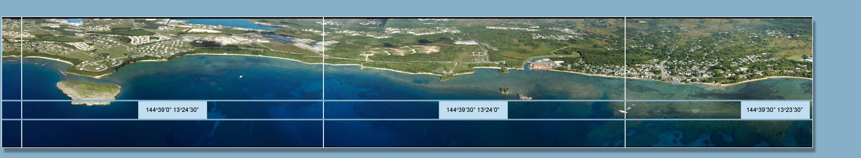
Fig. 8: Part of the continuous image of Guam's coast giving approximate latitude and longitude information.
Each of the above sets of annotations is superimposed on the continuous image, giving the user the opportunity to chose whether or not to display them. This can be done within the project's user interface, but is easier to do using the original file and specialized software. Downloading the image file in higher resolution accords the user the option to manipulate the file in graphics software such as Photoshop®. In addition to switching annotation layers on and off, the user can zoom in and out, copy, paste, or crop any portion, and modify the image in an unlimited number of ways. One suggested use is creating customized annotation layers, e.g., locations of favorite SCUBA dive spots.
INDEXING
DATABASE AND USER INTERFACE
CONCLUSION
ACKNOWLEDGMENTS