Faculty
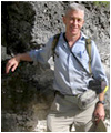 |
John Jenson Ph.D.
Professor of Environmental Geology
Phone: 671-735-2689 (fax 734-8890) (GMT+10 hrs)
jjenson(weriguam)uguam.uog.edu?subject=Faculty - WeriGuam.org
|
Recent Projects
Comparison of the past 60-year Coral Record from Guam with Instrumental & Proxy Records. 2011 MS thesis research by Tomoko Bell
This project was a collaborative project with Drs. John Jenson and Mark Lander at WERI, and Drs. Jay Banner, Ben Hardt, and Jud Partin of the University of Texas-Austin. The immediate objective was to closely interpret the past 60 years of a coral record from Guam in terms of contemporaneous instrumental records, such as regional sea-surface temperature and the ENSO Index. This will provide the basis for more accurate and precise interpretation of more ancient records. In addition to new insights into the coral record of the recent climate on Guam (Bell et al., 2011a) this project produced a novel pneumatic drill that will enable efficient collection of additional core in Guam’s coastal waters (Bell et al., 2011b). (Funding sources: Guam Hydrologic Survey; NOAA; US Geological Survey)
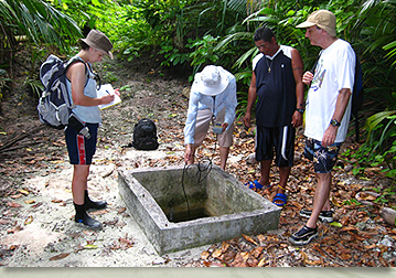
Geomorphic Responses to Sea-Level Change at Ritidian Point, Guam, Mariana Islands: 2011 MS Thesis by Blaž Miklavič
This was a collaborative field project initiated by Dr. Jenson of WERI and Dr. John Mylroie of the Department of Geosciences at Mississippi State University, with laboratory support by Dr. Jay Banner of the Jackson School of Geosciences at the University of Texas-Austin. Field surveys of caves and other sea-level indicators, combined with dating of speleothems found in the caves, have provided new insights into the MIS 5e sea-level history of Guam and the interglacial reef recently mapped as the Tarague Limestone (Siegrist and Reagan, 2008, below). (Funding sources: US Geological Survey; Guam Hydrologic Survey; NOAA).
Soil Moisture Model for Evapo-transpiration and Recharge in Northern Guam: 2009 MS Thesis by Nate Habana
The product of this project (Habana et al., 2009) was more accurate model for evaluating water loss and infiltration through the soils on the Northern Guam Lens Aquifer (NGLA). It includes a routing routine to efficiently compute the delay times for percolation and fast flow through the 60 to 180-m thick vadose zone of the NGLA. (Funding source: Guam Hydrologic Survey)
Atoll groundwater modeling: 2008 MS Thesis by Ryan Bailey
This project produced a high-resolution 2-D SUTRA model of an idealized atoll aquifer (Bailey et al., 2009), which provided the basis for a simple algebraic model for application to water resource management in the Federated States of Micronesia (Bailey et al., 2010). (Funding source: US Geological Survey)
Background Fluorescence in Guam's Groundwater: 2007 MS Thesis by S. Michelle Hoffman
Completed September 2007 (Hoffman, 2007), this project provided a comprehensive assessment of the background fluorescence in the groundwaters discharging into Guam's coastal waters. The results will facilitate better design and more accurate interpretation of dye trace studies on Guam and other coastal areas with similar aquifers and climate. (see: WERI Technical Report 121) describes the project and the results. A manuscript is in preparation for publication. (Funding source: Guam Hydrologic Survey)
Disturbed State Constitutive Modeling of Pleistocene Tills
This project (Desai et a., 2011; Sane et al., 2008) applied the Disturbed State constitutive model of Desai (2001) to evaluate the rheological characteristics of two Pleistocene tills (Carlson et al., 2004) deposited by the Laurentide Ice Sheet, with the objective of eventually providing an improved constitutive law for ice sheet modeling. A follow-on project is being proposed. (Funding source: National Science Foundation)
Update of the Geologic Map of Guam
Completed in 2008, this project produced the first update of the geologic map of Guam since the original map (Tracey et al., 1964) was published over 40 years ago. The map incorporates the results of more than two decades of fieldwork by Dr. Mark Reagan, University of Iowa, and Dr. Galt Siegrist (WERI professor emeritus) and their students to update the map, render it into GIS coverages, and expand it from 15-minute to 7.5-minute quadrangles. (Funding source: Guam Hydrologic Survey).
Back to top ^