Research Programs
SURFACE WATER AND WATERSHEDS
Soil Erosion Monitoring Programs
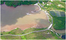
Surface runoff and sediment losses from soil erosion are major contributors to reduction in surface water quality and subsequent degradation of the coral reefs in Guam and the other islands in Western Pacific. The Guam Waterworks Authority (GWA) is presently pumping 4 million gallons per day from Ugum River in Southern Guam to the treatment facility. In recent years the GWA has faced an increasingly difficult task of keeping the plant operating at full capacity when the river is running with high turbidity rates. This highly turbid water has increased operational costs and along with poor operation and maintenance practices has led to premature failure of many components of the treatment plant system. Water that passes the Ugum treatment plant intakes eventually makes its way to the outlet of the river and into the estuary and reef environment. The negative impact of sediment loading on the aquatic environment of Guam is the degradation of coral reef, as well as negative impacts on fish populations and the tourism industry.
WERI researchers have undertaken projects aiming at various methods for estimating upland soil erosion and soil conservation practices. In a project funded by the National Oceanic and Atmospheric Administration (NOAA), WERI researchers developed a GIS based erosion model for the Ugum Watershed. This model, which integrates the Universal Soil Loss Equation (USLE) with the ESRI GIS software package, predicts the soil erosion potential within a watershed and also identifies the areas with highest soil erosion potential. The model is currently used to explore various soil erosion practices with their accompanying costs to determine the optimum erosion control practice that is most effective in reducing soil losses and is most cost effective.
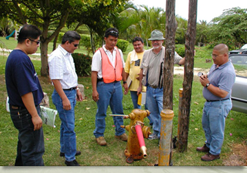
For more information send and email to Dr. Khosrowpanah:
khosrow(weri)uguam.uog.edu?subject=Soil Erosion Monitoring Programs - WeriGuam.org