Weather and Climate
Climate History Program
Why Cave Studies?
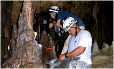
One the most productive sources of long-term pre-historic climate data is speleothems, i.e., calcite mineral deposits precipitated from cave dripwater. With current techniques, stalagmites (which develop distinct and datable layers, like tree rings, as they accumulate on the floors of caves) can reveal datable changes in chemical parameters that can be resolved at intervals ranging from seasons to millennia and spanning decades to hundreds of millennia. Changes in the amount or sources of rainfall, and sometimes even in above-ground temperature, can be inferred from the chemical clues and changes in rate of growth, especially if the relationship is known between the chemistry of modern calcite layers and the dripwater from which they precipitate. Fortunately, WERI researchers working over the past decade (Mylroie et al., 2001; Taboroši, 2004; Taboroši et al., 2004) have identified and mapped a number of accessible caves on Guam that contain promising stalagmite records from which the pre-historical climate record of Guam might thus be reconstructed.
What we've learned so far?
The caves in the Mariana Islands are products of complex speleogenetic processes that include successive episodes of limestone deposition and dissolution associated with tectonic uplift and subsidence, as well as eustatic sea level changes.
From a stalagmite previously collected on northern Guam, we have already measured stable oxygen isotope ratios and trace elements (Mg/Ca and Sr/Ca) and determined a chronology from 12 high-precision TIMS U/Th dates (Sinclair et al., 2008). The geochemical record spans 28,000 years, providing a time-series of changing hydrology and climate in the equatorial Pacific bracketing the Last Glacial Maximum through the present. Patterns in the geochemical parameters are consistent with those found in several other Pacific speleothems (from Vanuatu and the Solomon Islands), suggesting a large hydrological change in the Western Pacific during the Early-to-Mid Holocene, about 5,000-9,000 years before present. However, additional records are needed as the current archive is inadequate to completely describe the change. Additional insights gained from this and related ongoing collaborative projects will enable us to continue this line of research to determine more recent as well as longer-term climate patterns with higher resolution.
Back to top ^
Why this is important locally?
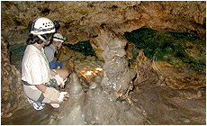
Data on dripwater rates and chemistry help improve the reliability of our interpretations of the chemical clues found in the cave deposits.
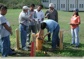
At its September 12, 2008 meeting, the Guam Water Resources Advisory Council identified as one of its research priorities “expanding and updating the rainfall database for Guam,” to include long-term rainfall variability (Item 16, under Water Quantity Issues, Guam´s Critical Water Resources Research, Education And Training Needs). Unfortunately, the long-term historical record for Guam begins only at the end of World War II. Moreover, as current research on climate dynamics around the world reveals, regional climates everywhere are characterized by decadal, centennial, and even millennial scale oscillations. Even the oldest historical records-which date at best from the early Eighteenth Century-are too short to document such long-term cycles. It is becoming increasingly important for economic planners and managers, however, to be able to anticipate or understand the likely duration and severity, if not the causes, of long-term or persistent shifts in weather and climate patterns. Of particular interest in the west Pacific Ocean region are the patterns of flooding/drought, prevailing winds, and the frequency and severity of major storms, which are already known to follow cycles of decadal and longer duration. To characterize long-term rainfall and temperature patterns prior to the historical record, however, requires making estimates of them from proxies such as the stalagmite record that we are studying in this project.
Broader Implications of This Work: Regional and Global Climate Dynamics
This project dovetails with other ongoing efforts determine the history of the West Pacific Warm Pool (WPWP) from specimens in Borneo, the Philippines, Solomon Islands, and Vanuatu (Partin et al., 2007). The WPWP is believed to be of central importance to global atmospheric and oceanic redistribution of heat (Webster and Lukas, 1992). Unfortunately, however, the history of oceanic provinces is especially difficult to reconstruct since fossil evidence, such as cave deposits, is not preserved as it is in continental environments. The speleothems found in the caves of the small carbonate islands of the west Pacific Ocean, however, provide a unique and valuable resource for reconstruction of the climate history of this centrally important oceanic region of the Earth. The record from the Mariana Islands is of particular interest, since the archipelago brackets the northern margin of the WPWP, where it experiences a strong (wet-dry) seasonal signal (unlike provinces nearer to the equator). Moreover, since the Mariana Islands straddle the boundary, island caves can record how the WPWP expands, contracts, or shifts over time, whereas caves in more central locations, see little or no change over time. The Mariana Islands are also located where Pacific ENSO events produce strong and long-lasting droughts, which may be discernable in the speleothem record. A detailed understanding of the cave environment from which the speleothems have been extracted is thus of great value because it will enhance the reliability of data and inferences that may be made for a crucial part of the Earth´s climate engine.
Back to top ^
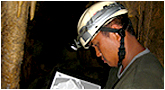
Getting a More Detailed Understanding of the Caves
Rainfall measurements and sampling of modern rainwater provide additional data for more reliable interpretations of the climate clues found in cave deposits.
WERI researchers are now seeking additional funding, which would support graduate thesis research in the University of Guam´s Environmental Science Program, to document the evolution of selected caves on Guam that are sources of climatic data for Guam in particular and the West Pacific region in general. Specifically, we hope to discern the sequence of events and conditions, including not only their relative timing but eventually their absolute ages as well, that produced each cave and the speleothems deposited in it (cf., Partin et al., 2008). Events and conditions on which the investigation will focus include the original environment and characteristics of the wall rock in which the cave formed and the onset of dissolution that initiated the development of the cave. We will also attempt to discern the subsequent history of uplift, subsidence, or eustatic relative sea-level fluctuations that emptied or flooded the cave with phreatic groundwater, as well as structural modifications, perhaps associated with seismic events, that shifted the relative positions of elements within the cave. Care will be taken to identify speleogenetic markers such as the onset and cessation of speleothem deposition or dissolution, and the emplacement of breakdown deposits within the cave. The detailed understanding of the cave history thus obtained will enable a more reliable assessment of the conditions under which the different deposits formed, as well as accurate inference of the environmental conditions of the island itself. This, in turn, will provide important insights and constraints by which more reliable interpretation can be made from the chemical parameters and patterns revealed by laboratory analyses on cave stalagmites. For example, we will be better able to determine whether a given shift in a chemical parameter in a cave stalagmite reflects a shift in the climate external to the cave rather than some change in the internal environment of the cave. It will also provide a basis for more systematic and efficient selection of future specimens for laboratory study, which will help lead researchers to the most informative specimens and minimize cost by preventing redundancies and duplications of studies of similar specimens. We will eventually also be able to correlate events noted in various caves to determine whether events are unique to a given cave or reflect island-wide or broader, regional changes in conditions.
Back to top ^
REFERENCES
- Mylroie, J. E., J. W. Jenson, D. Taboroši, J. M. U. Jocson, D. T. Vann, and C. Wexel, 2001, Karst features on Guam in terms of a general model of carbonate island karst: Journal of Cave and Karst Studies, v. 63, p. 9-22.
- Partin, J. W., K. M. Cobb, J. F. Adkins, B. Clark, and D. P. Fernandez, 2007, Millennial-scale trends in west Pacific warm pool hydrology since the Last Glacial Maximum: Nature, v. 449, p. 445-456.
- Partin, J. W., K. M. Cobb, and J. L. Banner, 2008, Climate variability recorded in tropical and sub-tropical speleothems: PAGES News, v. 16, p. 9-1.
- Sinclair, D. J., J. L. Banner, F. W. Taylor, T. M. Quinn, J. W. Jenson, and J. E. Mylroie, 2008, Deglacial climate dynamics in the western Pacific Ocean measured in a stalagmite from Guam, Goldschmidt Conference, Vancouver, B.C.
- Taboroši, D., 2004, Field Guide to the Caves and Karst of Guam: Honolulu, Bess Press, 105 p.
- Taboroši, D., J. W. Jenson, and J. E. Mylroie, 2004, Karst features of Guam, Mariana Islands, Mangilao, Water & Environmental Research Institute of the Western Pacific, University of Guam, p. 26.
- Webster, P. J., and R. Lukas, 1992, TOGA COARE - The coupled ocean-atmosphere response experiment: Bulletin of the American Meteorological Society, v. 73, p. 1377-1416.
Back to top ^