|
GRADUATE STUDENTS GATHERING
DATA FOR WETLANDS PROJECT
Wetlands on Guam occur predominantly
in the southern one half of the island. This is
an underpopulated region of small coastal villages
separated by steep and rolling topography etched
into volcanic rocks. Terrains are variously covered
with grasslands or ravine forests, or they have
degenerated into badlands. End-member wetland
types include tidal estuarine, tidal riverine,
non tidal riverine, permanent palustrine, and
ephem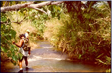 eral
palustrine, but combinations of these are common.
Their origin, distribution, evolution, and vulnerability
are related to bedrock geology, soil and slope
processes, tectonics, sea level changes, and to
land use modifications. Their function and value
as to flood control and affecting water quality
are the subject of considerable research at WERI. eral
palustrine, but combinations of these are common.
Their origin, distribution, evolution, and vulnerability
are related to bedrock geology, soil and slope
processes, tectonics, sea level changes, and to
land use modifications. Their function and value
as to flood control and affecting water quality
are the subject of considerable research at WERI.
This project is aimed at developing a geochemical-sedimentation
model that describes the flux of metals and nutrients
being stored and moving through a perennial palustrine
wetland downslope from a large tract of badlands.
The study involves establishing hydrologic parameters,
measuring slope retreat and sediment throughput
out of the badlands, and chemically analyzing
surface runoff and wetland pore waters, the latter
through a gridded lysimeter array in the wetlands.
Preliminary analysis of pore waters indicates
that the wetlands are mobilizing and storing iron
and manganese that enter from the badlands via
groundwater seepage and in suspension. Concentrations
of those metals may exceed three orders of magnitude
beyond normal Guam river waters.
The project has been funded by the
Government of Guam, Bureau of Planning. Future
related research will involve a) analyzing geochemical
cycling in tidal riverine and estuarine wetlands,
b) quantifying badlands denudation rates, c) studying
geochemical reactions involving manganese and
iron in the wetlands and downstream at the coast
where they are co-precipitate on reef debris.
For More Information on Wetlands
Projects send e-mail to Dr. H. Galt Siegrist:
[email protected]
|